International Symposium on
(PDF file of this page)
Organized
by National Resilience Promotion Office,
Cabinet Secretariat, JAPAN
http://www.cas.go.jp/jp/seisaku/kokudo_kyoujinka/index_en.html
With Faculty of Societal Safety Science, Kansai
University
http://www.kansai-u.ac.jp/Fc_ss/english/index.html
Supported
by Resilience Practice Unit, Kyoto
University
http://trans.kuciv.kyoto-u.ac.jp/resilience/
[PROGRAM
outline]
Day 0 January, 10 Welcome Reception (Nagoya)
- from 5:00 pm at Meitetsu Grand Hotel
Day 1 January, 11 Field trip (Nagoya)
-
start from Meitetsu Grand Hotel at 7:30 am, and arrival at the Hotel in Osaka in
the evening.
- Visit:
earthquake resilience museum, a local shrine, a well-known dam and an embankment
and a flood resilience museum in Nagoya
Day 2 January, 12 Workshop (Osaka)
- 9:00am – 5:00 pm workshop at Kansai
University
- 7:00pm – conference dinner
Day 3 January, 13 Workshop (Osaka)
- 9:00am – 2:30 pm workshop at Kansai University
Day 4 January, 14 optional tour (Kobe)
- meeting at the hotel at the Marrot hotel at 8:15am, trip to Kobe and
return to Osaka at 6:00pm.
- town walk and museum tour showcasing
examples of community led recovery following Kobe earthquake, presentations and
free discussion with local community members regarding community led
development (Machizukuri) after the Kobe Earthquake
[PROGRAM
details]
Day 0 January 10, Welcome
Reception
-
from 5:00 pm at “Sky Lounge 203” 18th Floor in Meitetsu Grand Hotel
1-2-5,
Meieki, Nakamura-Ku, Nagoya, Aichi, JAPAN 450-0002, Tel : (+81)052-582-2211 Fax : (+81)052-582-2230
(http://www.meitetsu-gh.co.jp/en/)
Day 1 January 11 – Technical Tour
-
Meeting
in the lobby (11F) of the Meitetsu Grand Hotel at 7:30 am.
-
Whole
day tour by bus to go to museum regarding earthquake resilience, shrine, dam,
embankment and museum regarding flood resilience in Nagoya (details can be seen
in the APPENDIX)
-
Arrive
at respective hotels in Osaka around at 6:00pm
Day 2 January 12 – Workshops in Kansai University
Venue: Special Conference Room, 12F of West Building Takatsuki Muse Campus,
Kansai University (7-1 Hakudaicho, Takatsuki-shi, Osaka, 569-1098, Japan)
Map of the Campus: http://www.kansai-u.ac.jp/English/about_ku/muse_map.html
Map of the location of Takatsuki Muse Campus: http://www.kansai-u.ac.jp/English/about_ku/location.html#muse
9:00 – 9:20 Opening / Greeting by Representatives of Resilience Promotion
Office, Cabinet Secretariat, JAPAN and Faculty of Societal Safety Science,
Kansai University
- Masato Koumura, Councillor, Cabinet Secretariat
- Toshihiro Kawaguchi, Ph.D. Deputy Dean, Faculty of Societal Safety
Sciences, Kansai University.
9:20 – 10:10 Keynote
lecture: Institutional Evolution Strategy for National Crisis in Japan
- Prof. Kawata, Kansai Univerisy, Central Disaster Management Council, Japanese
Government
10:10 – 10:45 How it all started: disaster-prevention-and-reduction-new-deal policy
- Prof. Satoshi Fujii,
Kyoto University, Special Advisor to the Cabinet
10:45 – 11:20 National resilience program:
successes and challenges
Presentation from National Resilience Promotion Office, Cabinet Secretariat, JAPAN
- Building Capabilities to Support Resilience in the U.S. (By Katherine Fox,
U.S. Department of Homeland Security Federal Emergency Management Agency)
12:00 – 13:00 LUNCH
13:00 – 15:00 Presentations by all international participants: Resilience – latest developments
and challenges(2)
- Ministry of Interior Directorate for Crisis management and Civil Protection
(By Friederike Dahns, Directorate for Crisis management and Civil Protection, Ministry of Interior, Head International Relations and Chair NATO Civil Protection Group.)
- National Security Strategy 2015: Current UK resilience priorities
(IanWhitehead, Deputy Director, Civil Contingencies, Cabinet Office. UK)
- From managing disasters to managing risks- guided by the Sendai Framework for Disaster Risk Reduction (By Mette Lindahl Olsson, Senior Adviser, Swedish Civil Contingencies Agency, MSB)
- Disaster resilience - latest developments and challenges: Australia's
experience. (By Elizabeth Quinn, Attorney-Generral's Department, Australia)
15:00 – 15:30 Afternoon
tea
15:30 – 17:00 Group
discussion / workshop: What are the key
developments and challenges for national resilience programs?
19:00 (General Discussion on Resilience over) Symposium Dinner at Courtyard Marriot, Shin-Osaka Station
Day 3 January 13 - Workshops in Kansai University (tentative program)
Venue: Special Conference Room, 12F of West Building Takatsuki Muse Campus, Kansai University
9:00 – 9:30Challenges Regarding Long-term Recovery after the1995 Great Hanshin-Awaji
Earthquake
(By Mampei Hayashi, Researcher, Asia Pacific Institute of Research)
9:30 – 10:00 How did recovery policies from 2011 disaster promote
or reduce local resilience?'
Prof. Shingo Nagamatsu, Faculty of Societal Safety Science, Kansai
Univerisy.
10:00 – 10:45 Presentations by all international participants: Resilience
- latest developments and challenges(3)
- Singapore’s Resilience Landscape, Thoughts on Resilience in the Singapore
Context
(Sunit Singh, Prime Minister's Office, Singapore)
-A Calculation Methodology of Disaster Damage Costs Based on a Resilience
Triangle & Korean Experiences
(Seungjae Lee, University of Seoul, Korea)
10:45 – 12:00 Special presentations on community resilience from international
participants, and free discussions
- Canada's Approach to Strengthening Community Resilience
(By Durand Stephanie, Director General, Emergency Management Policy and Planning Directorate, Public Safety Canada)
- Social Media, Crisis Management, and Community Resilience
(Senior Fellow, Swedish National Center for Crisis Management Research
and Training, Sweden)
-Resilience and the Japanese practice of Machizukuri
(By Ljubica Seadon, Director, Seadon Consulting & Research, formerly
in charge of national resilience programme)
12:00 – 13:00 LUNCH
13:00 – 14:30 Workshop: what to take away from this symposium?
Day 4 January 14 – Optional Tour
Meeting at Hotel Lobby at 8:15 am
(trip
by train)
10:00am
Disaster Reduction and Human
Renovation Institute (DRI): Participants can see the museum of the 1995
earthquake, and hear stories from the survivors. See the link below for more
information http://www.dri.ne.jp/en.
(trip
by train)
12:15am Lunch
1:30pm Mikura area, Nagata ward (Following
activities will be provided by Machi-communication, a notable local NGO that has
been involved in recovery of the area.
-
Presentation about the reconstruction and
recovery process of Mikura area,
-
Town walking,
-
Discussion with local residents about local
resilience.
(For
more information on Machi Communication,
http://park15.wakwak.com/~m-comi/project/25/m-comi-info-Eng-ver.pdf
http://park15.wakwak.com/~m-comi/project/25/m-comi-manu-Eng-ver.pdf )
(trip by train)
18:00
Break up at Shin-Osaka station
[Accommodation]
1)
See separate document of “Accomodation information for International Symposium on Resilience in
Japan,”
2)
Fill in “application_form_mwt.xls,
”
3)
Send it to Satoshi Fujii, fujii@trans.kuciv.kyoto-u.ac.jp.
[Symposium
Fee]
-
If you select tour options A, B, C or D, the
fee for the options includes the symposium fee. If you book hotels by yourself,
we will ask for the symposium fee of JPE 10,000.
-
We will ask you payment of the fee for the optional
tour on the day that will include transportation, lunch, admission fee of DRI, that
would be just few thousands JPE.
[Flight and Transportation to Nagoya]
-
For the 1st day technical tour, Central Japan
International Airport (Chubu Centrair, International Airport, Nagoya) will be
convenient. http://www.centrair.jp/en/. It will be
around 40 minutes from the airport to the Nagoya station, by train (Meitetsu
Limited Express).
-
You can fliy to other international airports in
Japan (such as Kansai, Narita or Haneda), and it is convenient for you to go
from these airport to Nagoya by Shinkansen train.
APPENDIX:
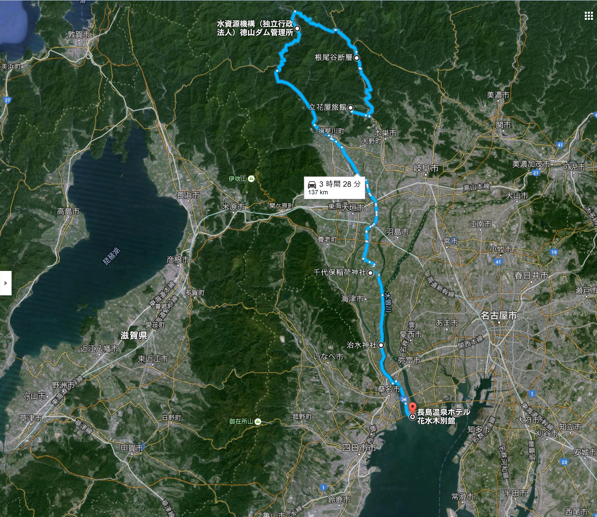
STUDY TOUR PLAN(2017/1/11)
Schedule(11 Jan)
7:30
meeting at Meitetsu Grand Hotel 11F Lobby
9:30 [Inspect 1] Neodani fault & museum 10:10
Dep.
11:20 [Inspect 2] Leaning museum of nature and
hydrology
11:40 Dep.
13:10 [Inspect 3] ”WAJU”~Circle Levee: prevented
1976 flood disaster 13:40 Dep
14:00 [Lunch] with Presentation by Mayor of Kaizu City
15:00 Dep.
15:25 [Inspect 4] “Chisuijinja-shrine” etc.
16:10
Dep.
16:30 [Inspect 5] Embankment for storm surge
16:45 Dep.
(via. Shin-Meishin expressway)
at about 19:00,
arrive at OSAKA
[Inspect 1] Neodani fault & museum
This is a large fault of 6m high and 8m wide (at their largest), which appeared on the earth’s surface around the Midori area in Neo village (present Motosu city) that was the seismic center of the Noubi earthquake. The Noubi earthquake occurred in October 1891, killing 7,273 people and completely destroying 142,177 houses.
As a result of investigation, a fault about 80 km long from Aichi-ken to Fukui-ken was discovered, and the part of the fault which had appeared on the earth’s surface was named the "Neodani Dansou (fault)."
In 1927, the fault was designated as a national natural monument. And in 1952, it was designated as a special national natural monument. In 1988, the village of Neo, together with specialists, started seeking some means to permanently preserve the fault as a historic heritage. As a result of the investigation, the village decided to dig the ground to make a trench which would enable visitors to view the fault from underground, and established there "the Neodani fault museum" including the trench.
[Inspect 2] Learning museum of nature and hydrology
The Tokuyama Dam is a multi-purpose dam located on the upper stream of the Ibigawa river. Its purposes are flood control, the maintenance of normal non-specified river flow, the development of new water supply, and hydropower generation. The dam was completed in 2008. Its total capacity is 660 million m2 (including 123 million m2 for flood control). It is the largest multi-purpose dam in Japan.
The mean annual precipitation of the Tokuyama area in Ibigawa town where the catchment area of the dam spreads is 2,862mm, which is 1.7 times as much as the mean annual precipitation of Japan (1,690mm). In some years, it rains even over 3,000mm per year. So, the flood control function of the Tokuyama dam is very important to deter flood disasters in the lower reach, which have repeatedly occurred. The Tokuyama dam is now functioning as a flood controller in cooperation with the Yokoyama dam located just below the Tokuyama dam.
On the other hand, in the neighboring areas of the Ibigawa basin, water supply shortages sometimes happen. So, a water conveyance program that uses the Tokuyama dam’s water capacity is being promoted.
【Inspect3】"WAJU"
~Circle Levee~: prevented 1976 flood disaster
The lower-middle reaches of the Ibigawa river run close to two other big
rivers, the Nagaragawa and the Kisogawa. Until about the 19th century,
these three big rivers had flowed meandering and crisscrossing as if making
a web of water. Therefore, villages in this area were formed into islands
surrounded by these river flows. So, circle levees were constructed surrounding
every village to protect inhabitants from flood disasters. This circle
levee is called “WAJU”.
Since the second half of the 19th century, the WAJUs, losing their role, were leveled down one by one, because the modern countermeasures for floods had been strengthened such as the separation of the three big rivers, the construction of embankments, and widening of river channels.
But the Jurenbou-levee, the inspection point
here, is preserved as it was although two entrances to the village were cut
out.
In heavy rain in September 1976, a part of the embankment of the Nagaragawa river in Anpachi town broke down, and a muddy stream began to flow into Wanouchi town located downstream.
The mayor of Wanouchi town ordered the town residents to evacuate, and quickly blocked the two entrances of the Jurenbou levee with sandbags. Thus, Wanouchi town escaped from the flood disaster.
【Inspect4】Chisuijinja-Shrine
At the lower reaches of the Ibigawa river, when it heavily rained, first, the water level of the Ibigawa river rose, followed by that of the Nagaragawa river after several hours, and finally, that of the Kisogawa river. This relayed and prolonged water level raising, caused by the differences of the lengths of the three big rivers, was one of the main causes of the flood damages in this area. So, about three hundred year ago, people in this area had petitioned the Edo Shogunate Government to separate the three big rivers from each other.
In December 1753, the Edo Shogunate ordered the Satsuma Clan to conduct the Kiso-Sansen Tripotamia Flood Control Works (knows as the Horeki Flood Control Works).
The Satsuma Clan began these construction works in 1754, and one and a half years later, they completed the embankment which separated two rivers, where the Chisuijinja-shrine is now located (Senbonnmatubara). This embankment has contributed to dramatically decreasing the damage from floods since then. But, the construction works were so difficult that many samurai of the Satsuma Clan died in performing the duty, and the work’s leader Yukie Hirata (minister of the Satsuma Clan) killed himself by hara-kiri, taking responsibility for the many samurai who lost their lives and the huge expenditure.
In 1938, the Chisuijinja-shrine was built to enshrine the spirit of Yukie
Hirata and many Satsuma Samurai.
Actually, the construction of the Kiso-Sansen Tripotamia Flood Control Works was not completely finished by Satsuma’s works in 1754. It was the works conducted under the guidance of Johannis de Rijke, a Dutch civil engineer, from 1887 to 1912 that completed the Tripotamia Works including the change of the river course of the Kisogawa river. The works roughly created today's landscape of this area.
Now, we can learn information in detail on these three rivers at the exhibition in Kisosannsenn park near Chisuijinja shrine. We can also see the three big rivers from the observation tower in the park.
[Inspect5] Embankment
for storm surge
The Isewan typhoon (1959) made a big storm surge. This storm surge overlapped with the high tide of the Isewan bay and broke many parts of the embankment in the river mouth of the three big rivers.
Since the elevation of Nagasima town, where we will visit, is below sea level, the whole town was submerged by the flood water for a long time and many people perished.
After this disaster, the embankment, where we will visit, was reconstructed to protect the town from a storm surge of the Isewan typhoon class.
Then, because the ground around here has been sinking, some repair and enforcement works of the embankment for storm surges are progressing now.
[The others]
We can see small buildings through the windows of the bus, which are called
"Mizuya," on the sides of houses in this area. Mizuya are built
on the ground several meters higher than their surroundings, and are protected
by stone walls. Usually, they serve as warehouses, but when a flood comes,
they become shelters. Mizuya are one of the time-honored countermeasures
which shows our ancestors’ preparedness against floods.
After the tour, we will move for Osaka via the Shin-Meishin expressway. The Shin-Meishin expressway complements the Meishin expressway which was constructed in 1960, and gives us redundancy by constituting a double highway system on the main axis of land transport of Japan (Tokyo-Nagoya-Osaka).